
Met Office Issues Rare Red Extreme Heat Warning as UK Heatwave Forecast to Hit 39°C Breaking a June Record Standing Since 1976
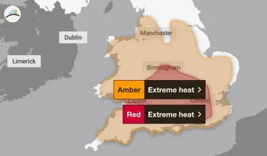
The Red warning, covering central and southern England and Wales from Wednesday 9AM to Thursday 9PM, is the highest alert level the Met Office issues and follows a series of escalating warnings since Friday, with Deputy Chief Forecaster Mark Sidaway stating health impacts are expected "even beyond those who are normally more vulnerable."
The Met Office has issued a rare Red Extreme Heat warning for parts of central and southern England and Wales, effective from 9:00AM on Wednesday, June 24 to 9:00PM on Thursday, June 25, 2026, as the United Kingdom braces for what forecasters now describe as a record-breaking and oppressive heatwave driven by an unusual combination of extreme heat and high humidity.
The warnings in full
The Red warning the highest alert level the Met Office issues, reserved for situations involving risk to life and major disruption was issued on Sunday, June 22, 2026, and covers Wednesday and Thursday. It sits alongside Amber Extreme Heat Warnings running from Monday through to Thursday night, covering much of southern and central England and much of Wales.
The UK Health Security Agency has separately issued a series of Yellow and Amber Heat Health Alerts specifically highlighting potential health and social care impacts across the same period.
Other Stories-
-Blood Pressure Medication Recall: FDA Lists Chlorthalidone Bottles Pulled Nationwide
-Clive Davis Dies at 94: Whitney Houston Mentor’s Legacy, Career and Net Worth Explained
Forecast temperatures and the record at risk
Temperatures are forecast to reach 34°C in southern parts of England on Monday, rising to highs of 37°C for southern England and 35°C in southeast Wales on Tuesday. The peak of the heatwave is forecast for Wednesday and Thursday, when temperatures are expected to climb to at least 39°C, with a chance of this being exceeded in some locations.
The current highest temperature on record for June in the UK is 35.6°C, recorded in Southampton in June 1976. The Wales June temperature record of 33.7°C set in 2000 is also likely to be broken.
By Friday, conditions will be less hot, with highs of 32°C forecast across eastern areas, as high pressure gradually moves east through the weekend.
Why this heatwave is different humidity
The Met Office has emphasised that humidity is what makes this event uniquely dangerous, distinguishing it from recent heatwaves including July 2022.
Dew points which indicate how humid the air is are forecast to reach around 22°C on Wednesday and Thursday. For comparison, during the record-breaking July 2022 heatwave, dew points were only in single figures, highlighting how oppressive this heatwave will be.
Met Office Deputy Chief Forecaster Mark Sidaway said: "Red warnings are reserved for the most severe events and we're expecting severe and significant impacts from this heatwave, with health impacts likely for many, even beyond those who are normally more vulnerable to the heat. The last time the UK recorded temperatures this high was in July 2022, but on this occasion the heat is expected to be accompanied by high humidity."
Tropical Nights across England and Wales
Overnight temperatures will be very high, with widespread Tropical Nights where the temperature does not drop below 20°C across parts of England and Wales, especially in urban areas. The Met Office has warned that consecutive tropical nights will make it very hard for people to recover from the daytime heat, significantly exacerbating heat stress impacts.
Health and infrastructure warnings
The Met Office warning highlights potential impacts across public health, transport, energy, and water supply. An increase in potential water safety incidents is also noted, as more people are likely to visit coastal areas, lakes and rivers.
The RNLI's National Water Safety Partner Samantha Hughes warned: "With warmer weather approaching, it is important to remember that the water is still cold. Entering it unexpectedly can lead to cold water shock, causing a sudden increase in breathing and heart rate, which may trigger panic. If you find yourself struggling in the water, remember to Float to Live: tilt your head back so your ears are submerged, relax and control your breathing."
Heatwave conditions, initially developing over southern and eastern England, are expected to persist well into next week, and will also spread into many other parts of England and Wales. Conditions in the northwest are expected to remain cooler and cloudier, with some light rain moving in at times.
Climate context
It is virtually certain that human influence has increased the occurrence and intensity of extreme heat events. Met Office projections indicate that hot spells will become more frequent in UK climate, particularly over the south-east, with temperatures projected to rise in all seasons.
The unique angle worth noting: the forecaster comparison between this heatwave and July 2022 the most extreme in UK recorded history actually reveals this event could be worse in lived experience, if not in peak temperature. The 2022 heatwave peaked at 40.3°C in Coningsby, Lincolnshire, but with dew points in single figures. This week's heatwave is forecast to peak at 39°C, but with dew points of 22°C a combination that the Met Office's own forecasters say makes it more oppressive than 2022, because high humidity prevents the body from cooling through perspiration. A lower temperature number on the thermometer this week could represent a more physically dangerous event for the population than the 2022 record.