
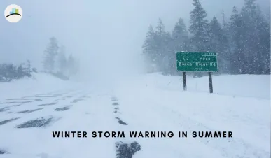
A strange burst of winter weather is interrupting summer plans across parts of the western United States, with winter storm warnings and weather advisories issued for high-elevation areas just days before July. The National Weather Service has warned of heavy wet snow, cold temperatures, gusty winds and dangerous backcountry travel conditions in mountain regions where Idaho, Montana and Wyoming meet, while a broader Pacific storm is also bringing snow chances to parts of the Cascades and Sierra Nevada. The key message for hikers, campers and mountain travelers is clear: this is not a city-level snowstorm, but it could become dangerous fast in exposed high terrain.
Where Is The Winter Storm Warning?
The most serious warning is focused on high elevations in the northern Rockies, especially parts of Montana near the Idaho and Wyoming border region.
The National Weather Service in Missoula issued a winter storm warning for the Butte/Blackfoot Region above 6,500 feet, including Georgetown Lake and nearby backcountry and higher-elevation areas. The warning was in effect until 9 a.m. MDT Monday, with heavy wet snow expected above 6,500 feet.
Men’s Journal also reported that winter storm warnings and winter weather advisories were issued for the region where Idaho, Montana and Wyoming border each other, with officials asking people to consider delaying backcountry and high-elevation travel.
SUMMER SNOW! ❄️🥶 New pictures coming in from Utah (left) and Montana (right). Over a foot of snow is possible in the hardest hit spots here on the doorstep of July! Credit: @AltaSkiArea and @DiscoverySki pic.twitter.com/uilsrXFEQR
— Matt Devitt (@MattDevittWX) June 28, 2026
How Much Snow Is Expected?
Snow totals vary by location and elevation.
The official National Weather Service warning for parts of Montana called for 4 to 8 inches of heavy wet snow above 6,500 feet, with 8 to 16 inches possible across the Anaconda Pintler Mountains. The same warning said snow levels could briefly lower enough to create minor slushy accumulation at Homestake and MacDonald Pass.
Men’s Journal reported that some higher mountain areas around the Georgetown Lake region could see much higher totals, with up to three feet possible from Saturday night through Tuesday. The larger message is that totals can change sharply by elevation, slope and exact storm track.
Why Is It Snowing In Summer?
Summer snow can happen in high mountains when a cold Pacific storm pushes inland and drops snow levels over elevated terrain.
This event is tied to a late-June storm pattern bringing colder air, moisture and strong winds into the West. Men’s Journal reported that the Weather Prediction Center was tracking snow into the Sierra Nevada and Cascades, including Washington, Oregon and California, with the greatest chance for accumulating snow at elevations above roughly 6,500 to 7,000 feet.
So this is not the same as winter returning to lowland towns. It is a high-elevation event where mountain weather can flip quickly, even while nearby lower elevations remain in summer mode.
Why High-Elevation Travelers Should Take This Seriously
The danger is not only snowfall totals. The bigger concern is the combination of wet snow, cold temperatures, wind and remote terrain.
The National Weather Service warned that cold temperatures, wind and wet snow could raise the risk of hypothermia. Heavy wet snow may also bring down trees and block access to backcountry roadways.
That matters for campers and hikers because a few inches of wet snow can collapse tents, soak gear and make trails harder to follow. Men’s Journal noted that campers were specifically warned that only a few inches of snow can damage tents and recreational items.
What About The 60 MPH Winds?
Strong winds are another major part of this weather system.
Men’s Journal reported that southwest winds across eastern and southern Nevada and surrounding valleys could gust up to 60 mph, creating fire danger near lower ranges. The same report also cited the National Weather Service Great Falls office warning that parts of north-central Montana could see gusts above 50 mph, causing difficult crosswinds.
In mountain areas, wind can make a storm feel much worse than the snow totals suggest. It can reduce visibility, increase wind chill, knock down branches and make travel more dangerous on exposed ridges and passes.
Is This A Major Winter Storm For Cities?
No. This is mainly a high-elevation and backcountry storm.
The biggest impacts are expected in mountains, passes and remote recreation zones. Lower-elevation cities may see rain, gusty winds or cooler weather, but the winter storm warning language is aimed at places where elevation is high enough for snow.
This distinction is important because headlines about “three feet of snow” can sound like a widespread winter disaster. The real risk is narrower, but still serious for anyone hiking, camping, driving mountain roads or crossing high passes.
Which Areas Could See Snow?
The northern Rockies are the main warning zone, but snow chances extend across several western mountain regions.
Men’s Journal reported snow moving into the Sierra Nevada and Cascades, including parts of Washington, Oregon and California, with accumulating snow most likely above 6,500 to 7,000 feet. It also mentioned the Uinta Mountains, the Northern U.S. Rockies and higher terrain in Idaho and Wyoming.
In Idaho, 4th of July Peak was expected to see around a foot of snow over three days, while Pitchstone Plateau in Wyoming was forecast for around eight inches, according to Men’s Journal’s summary of weather service data.
Why Lake Tahoe And Sierra Travelers Are Watching Closely
The Sierra Nevada and Tahoe region are also part of the wider cold-weather story.
KQED reported that a late-June storm was expected to bring wind, freezing temperatures and a chance of snow flurries around the Lake Tahoe region, with the strongest snow chances at higher elevations. The report also said ridgetop winds could reach 70 to 80 mph, while lake winds could create dangerous conditions for small boats.
That does not mean Tahoe is expecting a major accumulating snowstorm everywhere. It means people heading into the mountains or onto the water should not assume late June automatically means safe summer conditions.
Why This Warning Is Getting So Much Attention
This story is trending because “winter storm warning” and “summer” do not normally belong together in people’s minds.
By late June, many travelers are thinking about camping, road trips, hiking, boating and July 4 plans. A sudden warning for heavy wet snow and strong winds feels unexpected, especially in areas where people may not be carrying winter gear.
That surprise factor is exactly why the warning matters. Mountain weather does not care what season the calendar says.
What Should Travelers Do?
Travelers heading into affected mountain areas should check the latest local forecast before leaving and be ready to delay or change plans.
The National Weather Service advised people to consider delaying travel across backcountry and higher-elevation areas. If travel is necessary, it recommends carrying a winter storm kit with items such as tire chains, booster cables, flashlight, shovel, blankets, extra clothing, water and first aid supplies.
For campers and hikers, the basics are simple: bring warm layers, waterproof gear, food, water, a headlamp, map or GPS backup, and a way to receive alerts. Avoid exposed ridges during strong winds and do not rely only on summer clothing.
What Makes Heavy Wet Snow Dangerous?
Heavy wet snow is much denser than dry powder.
That makes it harder to walk through, harder to drive through and more damaging to trees and tents. Wet snow can also soak clothing and gear quickly, increasing the risk of hypothermia when temperatures fall and wind picks up.
The National Weather Service specifically warned that heavy wet snow could down trees and block backcountry roads in affected Montana areas.
Will This Affect July 4 Travel?
It could affect early-week mountain travel and backcountry plans leading into the July 4 period.
Men’s Journal reported that the storm comes just as many people are preparing for Independence Day travel and celebrations, with warnings asking people to consider delaying backcountry travel in the affected region.
The biggest concern is not fireworks in lowland towns. It is travelers heading into mountain roads, campsites, trailheads and high passes before conditions improve.
MORE ARTICLES:
Final Takeaway
A rare late-June winter storm warning is bringing heavy wet snow, cold temperatures and gusty winds to high elevations in parts of the western United States. The most serious warning is focused on backcountry and higher-elevation areas around Montana, Idaho and Wyoming, while the broader storm pattern is also raising snow chances in the Cascades and Sierra Nevada.
This is not a widespread low-elevation winter storm, but it is still dangerous for hikers, campers and mountain travelers. Anyone heading into high terrain should check official alerts, carry winter gear and be ready to delay travel if conditions deteriorate.